Critical zone
The Critical Zone


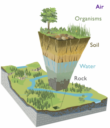
The Critical Zone is a term first adopted by the US National Research Council to describe the region of Earth’s surface that houses all life and the systems that support it. Officially, the Critical Zone is described as the “heterogeneous, near-surface environment in which complex interactions involving, rock, soil, water, air, and living organisms regulate the natural habitat and determine the availability of life-sustaining resources”.[1] From this original statement, many definitions have been crafted to determine the boundary of this zone, including all regions between the bottom of Earth’s weathering zone or aquifer base up to the top of the vegetation canopy. In layman’s terms, the Critical Zone is the Earth’s outer skin; the region where rock, soil, water, air, and all living organisms interact and work in tandem to shape the Earth’s surface.[2][3]
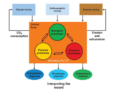
Complex biogeochemical-physical processes combine to transform rock and biomass into soil which in turn supplies much of the terrestrial biosphere with nutrients required for survival.[4] Simply put, the Critical Zone is the Earth’s life support system, and entire areas of study have been dedicated to understanding the complex processes and cycles that interact with one another to support Earth’s multitude of lifeforms.
Scale
Processes within the Critical Zone take place across an extremely wide temporal scale, ranging from multimillion-year time frames of plate tectonics and weathering to rapid transformations of short-term events like water cycling or impacts from pollutant introduction like heavy metals into soils.
Along with wide ranges in temporal scales, properties of the Critical Zone vary over distance. Soil composition, biomass type and availability, water resources, and overall climate all contribute to processes within the Critical Zone, making Critical Zone science a complex and interdisciplinary study.
The key to Critical Zone science is to use observatories as “time telescopes” that allow focusing not only on the processes occurring in present-day but allow for comparisons against past and future process records, as well as comparisons across distances to compare interactions and cycle influences.[3]
Critical Zone Observatories (CZOs)
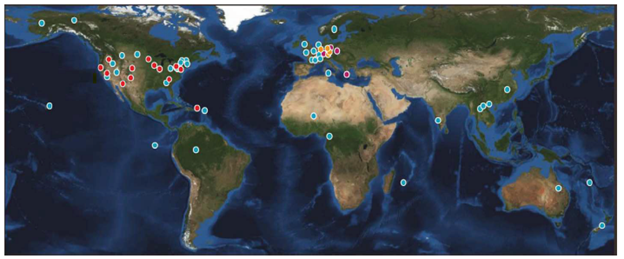
CZOs are natural watershed laboratories used to study various aspects of the Critical Zone with the intent of gaining a better understanding of its complex systems.[5] CZOs integrate the study of Earth’s surface processes, such as landscape evolution, weathering, hydrology, geochemistry, climatology, and ecology, across multiple spatial and temporal scales to study anthropogenic impacts on Earth’s vital systems. [3][7]
The research at each CZO includes field and theoretical approaches, as well as emphasizing education and outreach to students aged anywhere from K-12 to graduate levels. Although funded individually, the U.S. based CZOs work together to better understand scientific processes and impacts within the Critical Zone, aiming to increase their knowledge of how the CZ operates and evolves, with a key focus on looking into a predictive ability to how processes will respond to changes in climate and land use.[8]

NSF Funded Locations within the US and US Governed Territories[7]
| Observatory | Generalized Location | Climate | Land Cover | Area of Study | Status |
|---|---|---|---|---|---|
| Boulder Creek CZO | Colorado | Temperate, Subhumid | Alpine Tundra, Mixed Forest, Grassland/Herbaceous, Agriculture-Pasture, Developed-Low | Erosion and weathering impacts on Critical Zone architecture and evolution, concentrating on slope, climate, ecosystems, and rock properties | Active |
| Calhoun CZO | South Carolina | Humid, Subtropical | Grassland/Herbaceous, Mixed Forest | Impacts of reforestation efforts on hydrology, geomorphology, biology, and biogeochemistry in areas with serious agricultural land and water degradation | Active |
| Eel River CZO | California | Mediterranean, Hyper humid | Grassland/Herbaceous, Mixed Forest, Developed-High, Agriculture-Crops | Exploring how the Critical Zone will mediate watershed responses in changing environments. Climate change and ecosystem impacts within watersheds | Active |
| Intensively Managed Landscapes CZO | Illinois/Iowa/Minnesota | Temperate, Humid | Agriculture-Crops, Grassland/Herbaceous, Shrubland | Works to understand how land use changes effect of the long-term resilience of the Critical Zone | Active |
| Santa Catalina Mountains & Jemez River Basin CZO | Arizona/New Mexico | Temperature, Subhumid | Barren Land, Evergreen Forest, Grassland/Herbaceous, Mixed Forest | Measurements of geomorphic, hydrologic, and biogeochemical interactions that drive theory and modeling of Critical Zone evolution. Focuses on elevation gradients and impacts to arid/semi-arid systems | Active |
| Luquillo CZO | Puerto Rico | Tropical, Humid | Deciduous Forest, Developed-Low | How Critical Zone processes and water balances differ in landscapes with contrasting bedrock but similar climatic and environmental histories | Active |
| Reynolds Creek CZO | Idaho | Mediterranean, Dry | Grassland/Herbaceous, Evergreen Forest, Shrubland, Annual Grasses | Prediction of soil carbon storage and flux from pedon to landscape scales, focus on processes that govern carbon sequestration | Active |
| Susquehanna Shale Hills CZO | Pennsylvania | Temperature, Humid | Deciduous Forest, Agriculture-Pasture | Quantitative prediction of Critical Zone creation and structure, focusing on pathways and rates of water, solutes, and sediments | Active |
| Southern Sierra CZO | California | Mediterranean, Humid | Evergreen Forest, Shrubland, Grassland/Herbaceous | Investigates critical zone across mountainous elevation gradient, focusing on water balance, nutrient cycling, and weathering processes | Active |
| Christina River Basin CZO | Delaware/Pennsylvania | Temperate, Humid | Deciduous Forest, Agriculture-Crops, Developed-Low | Understanding of water, mineral and carbon cycle fluxes to better quantify human impacts on carbon sequestration in Critical Zones | Inactive |
References
[1] National Research Council. Basic Research Opportunities in Earth Science. 2000. nap.nationalacademies.org, https://doi.org/10.17226/9981.
[2] Giardino, J. R., C. Houser, and ScienceDirect (Online service). Principles and dynamics of the critical zone. Page 1 online resource. Developments in earth surface processes volume 19.
[3] Guo, L., and H. Lin. 2016. Critical zone research and observatories; current status and future perspectives. Vadose zone journal 15:1-14.
[4] Lin, H. S. 2009. Earth’s Critical Zone and hydropedology:65.
[5] White, T., S. Brantley, and S. Banwart. 2015. The Role of Critical Zone Observatories in Critical Zone Science. Pages 15–78 in Principles and dynamics of the Critical Zone. essayElsevier.
[6] Coddington, N. 2017. Explore the Critical Zone. Youtube. WSKG Public Media.
[7] Observatories: National critical zone observatory. (n.d.). . https://czo-archive.criticalzone.org/national/infrastructure/observatories-1national/.
[8] The Critical Zone: National Critical Zone Observatory. (n.d.). . https://czo-archive.criticalzone.org/national/research/the-critical-zone-1national/.