ROCKD: Difference between revisions
Created page with "=='''Overview'''== ROCKD is a website that is also available as an app on the App Store as well as the Google Play store. It is funded by NSF and UW Geoscience, and produced b..." |
No edit summary |
||
| Line 1: | Line 1: | ||
=='''Overview'''== | =='''Overview'''== | ||
ROCKD is a website that is also available as an app on the App Store as well as the Google Play store. It is funded by NSF and UW Geoscience, and produced by UW Macrostat Lab. | ROCKD[https://rockd.org/] is a website that is also available as an app on the App Store as well as the Google Play store. It is funded by NSF[http://nsf.gov/] and UW Geoscience[http://geoscience.wisc.edu/geoscience/], and produced by UW Macrostat Lab[https://macrostrat.org/]. | ||
[[File:Main.png|right|200px|thumb]] | |||
=='''Features and Usage'''== | |||
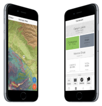
ROCKD features a host of services for Geologists and those curious about the [[bedrock]] and [[parent material]] or other features in your area and around the world. The main feature being a global map of bedrock layers and strike/slip faults. Any area on the map can be clicked on to open a window that lists the coordinates involved, the name, age, and type of rock or strike/slip fault, and a reference link to their data source. It additionally allows for users to add their own observations on rock formations, to tag and save features, to measure and record strike/slip fault data, and a searchable database. The app can be used without an account, but not edited. | |||
=='''References'''== | |||
[1]https://rockd.org/ | |||
[2]http://nsf.gov/ | |||
[3]http://geoscience.wisc.edu/geoscience/ | |||
[4]https://macrostrat.org/ | |||
Revision as of 13:45, 19 April 2019
Overview
ROCKD[1] is a website that is also available as an app on the App Store as well as the Google Play store. It is funded by NSF[2] and UW Geoscience[3], and produced by UW Macrostat Lab[4].

Features and Usage
ROCKD features a host of services for Geologists and those curious about the bedrock and parent material or other features in your area and around the world. The main feature being a global map of bedrock layers and strike/slip faults. Any area on the map can be clicked on to open a window that lists the coordinates involved, the name, age, and type of rock or strike/slip fault, and a reference link to their data source. It additionally allows for users to add their own observations on rock formations, to tag and save features, to measure and record strike/slip fault data, and a searchable database. The app can be used without an account, but not edited.