Soil erosion: Difference between revisions
No edit summary |
m The LinkTitles extension automatically added links to existing pages (<a rel="nofollow" class="external free" href="https://github.com/bovender/LinkTitles">https://github.com/bovender/LinkTitles</a>). |
||
| Line 48: | Line 48: | ||
== Restoration and Prevention == | == Restoration and Prevention == | ||
Removal of vegetation is generally a major accelerator of soil erosion, particularly large-scale anthropogenic methods like deforestation. Restoration of eroded soil often involves the revegetation of the area and the application of soil amendments to increase organic matter and water infiltration to aid plant growth. Agricultural practices like conventional tillage and monoculturing also increase soil erosion, as tillage loosens soil and monocultures reduce soil community biodiversity lowering overall soil health. A variety of best management practices (BMPs) are utilized in agriculture for the reduction of soil erosion. In the United States, these are implemented through several different government programs at the local, state, and federal levels. Relevant agencies include the USDA Natural Resources Conservation Service (NRCS) and county Soil and Water Conservation Districts. Some examples of BMPs that are commonly used in New York include: | Removal of vegetation is generally a major accelerator of soil erosion, particularly large-scale anthropogenic methods like deforestation. Restoration of eroded soil often involves the revegetation of the area and the application of soil amendments to increase [[Organic Matter|organic matter]] and water infiltration to aid plant growth. Agricultural practices like conventional tillage and monoculturing also increase soil erosion, as tillage loosens soil and monocultures reduce soil community biodiversity lowering overall soil health. A variety of best management practices (BMPs) are utilized in agriculture for the reduction of soil erosion. In the United States, these are implemented through several different government programs at the local, state, and federal levels. Relevant agencies include the USDA Natural Resources Conservation Service (NRCS) and county Soil and Water Conservation Districts. Some examples of BMPs that are commonly used in New York include: | ||
Contouring: Uses ridges and furrows to alter the direction of runoff, so that flow paths run around the hillslope rather than directly downslope [8]. | Contouring: Uses ridges and furrows to alter the direction of runoff, so that flow paths run around the hillslope rather than directly downslope [8]. | ||
Revision as of 13:04, 6 May 2022
Definition
Soil Erosion is defined as the gradual wearing away of topsoil over time. It is caused by many processes relevant to (but not limited to) climate, geomorphology, ecology, and human activity.
Types of Soil Erosion
Water Erosion

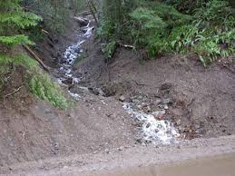
Water erosion occurs when water, either from rain or running water on the surface, causes the topsoil to wear away. The best way to restore soil that has been eroded by water or is being eroded by water is to introduce vegetation to the soil. The roots will help keep the soil in place as well as absorb some water to decrease the effects of water erosion. Water erosion is most prominent in areas where there is a lot of rain and in areas with many streams/springs. There are many kinds of water erosion that range from the splash of raindrops disturbing the surface of the soil to rivers and streams washing out banks in the soil.
Splash Erosion - Soil particles are disturbed and moved by rain droplets impacting the ground.
Sheet Erosion - Heavy rainfall causes water to move downhill as a sheet rather than in a channel wearing away the topsoil across a wide area.
Rill Erosion - Small rills are formed were rain or spring water gathers and erodes a small channel in the ground.
Gully Erosion - Larger versions of Rills that can erode deep into the soil.
Valley/Stream Erosion - Constant water movement causes V shaped channels in the soil that can become actual streams given enough time and rainfall.
Bank Erosion - High banks on the sides of rivers and streams are worn away by the constant flow of water until the bank collapses into the river.
Wind Erosion

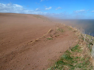
Wind erosion occurs when gusts of wind spread topsoil varying distances based on how fine the soil is. Very fine soils are spread far while larger grained soils are carried shorter distances. Wind erosion is most prominent where there are no windbreaks such as trees, shrubs, or buildings to cut off the wind. Grass can also aid in reducing wind erosion by acting as a cover for the soil. Wind erosion usually occurs where there is little cover to break the wind and where soil is the driest. There are 3 names for the different ways soil is transported by wind.
Suspension - Small soil particles are lifted extremely high into the air and can be brought miles away from where they started.
Saltation - Loose soil is lifted then they drift horizontally to the ground gaining momentum with the wind. Saltation is the most common form of wind erosion and can cause a lot of damage to the surface of the soil.
Creep - Larger particles that are too heavy to be lifted are pushed across the ground and are often pushed further by the particles being thrown by Saltation.
Biotic Erosion
Biotic erosion occurs when living organisms (can refer to wildlife or human activity) cause or accelerate soil erosion. Various agricultural threats exist, such as the overgrazing of vegetation and the loosening of topsoil from trampling by livestock. Other threats exist that are purely anthropogenic, such as construction projects, that remove sources of shear strength (i.e. vegetation) and increase hillslope soil loss.
Restoration and Prevention
Removal of vegetation is generally a major accelerator of soil erosion, particularly large-scale anthropogenic methods like deforestation. Restoration of eroded soil often involves the revegetation of the area and the application of soil amendments to increase organic matter and water infiltration to aid plant growth. Agricultural practices like conventional tillage and monoculturing also increase soil erosion, as tillage loosens soil and monocultures reduce soil community biodiversity lowering overall soil health. A variety of best management practices (BMPs) are utilized in agriculture for the reduction of soil erosion. In the United States, these are implemented through several different government programs at the local, state, and federal levels. Relevant agencies include the USDA Natural Resources Conservation Service (NRCS) and county Soil and Water Conservation Districts. Some examples of BMPs that are commonly used in New York include:
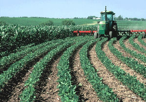
Contouring: Uses ridges and furrows to alter the direction of runoff, so that flow paths run around the hillslope rather than directly downslope [8].

Grassed waterway: This is a broad, graded channel covered with grasses used to divert runoff from agriculture in a way that reduces soil erosion and sediment discharge into the watershed [10]. These can often be implemented in a ways that benefit wildlife, such as the use of pollen-producing plants on the edges of the grassed waterway [10].
Cover Cropping: This consists of seasonally planting grasses, grains, or legumes on cropland that would otherwise be left idle until the next annual crop is planted [9]. The vegetation cover and root systems reduce soil erosion, add organic matter, and increase infiltration into the soil [9].
Modeling
There are a variety of modeling techniques that are used to predict and analyze soil erosion. The Universal Soil Loss Equation (USLE) is an empirical equation developed for estimating annual soil loss, accounting for multiple factors and processes that occur in a landscape. The equation reads A (average annual soil loss) = R x K x LS x C x P. The factor R represents climate (specifically the rainfall erosivity), K represents the soil erodibility factor, LS represents topography in terms of the slope factor, C represents the land cover factor, and P represents the land management practice factor [6].
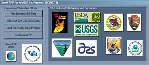
Researchers from the USDA Agricultural Research Service (ARS) continued to refine the USLE in the decades after its creation, which led to the Revised Universal Soil Loss Equation (RUSLE), and the Water Erosion Prediction Project (WEPP). The WEPP model is a computer program designed to predict soil erosion in small watersheds at small or large temporal scales, simulating a myriad of processes related to climate, topography, hydrology, and land management [6]. To further the usefulness and accessibility of WEPP, the Geospatial Interface for the Water Erosion Prediction Project (GeoWEPP) was developed by researchers from USDA-ARS and the University at Buffalo to provide a Geographic Information Systems (GIS) interface for potential WEPP users, in the form of an ArcMap extension [5]. This allows users to run WEPP using their own GIS input data. A digital elevation model (DEM) is required in order for GeoWEPP to delineate channels and watersheds, and soils and land cover data are optional [5].

The Soil and Water Assessment Tool (SWAT) is another useful computer program, developed by researchers from USDA-ARS and Texas A&M, to predict and quantify the effects of climate and land use on water quality from small-watershed to river-basin scales [11]. It is used for several watershed management concerns including soil erosion and non-point source pollution [11]. In 2013, researchers from SUNY Brockport published the results of several analyses conducted using SWAT in the Genesee River Basin (which is an agriculture-heavy watershed), including recommendations regarding the most effective BMPs for reducing phosphorous loads to Lake Ontario [4]. Grassed waterways were found to be the most effective when applied across the Genesee River Basin [4].
References
1. Causes of Water Erosion. (n.d.). . https://www.erosionpollution.com/water-erosion.html.
2. Heritage Te Manatu Taonga. 2012, July 13. 7. – Soil erosion and conservation – Te Ara Encyclopedia of New Zealand. Ministry for Culture and Heritage Te Manatu Taonga. https://teara.govt.nz/en/soil-erosion-and-conservation/page-7.
3. How human activities can accelerate soil erosion. (n.d.). . http://lcgeography.preswex.ie/how-human-activities-can-accelerate-soil-erosion.html.
4. Makarewicz, Joseph C.; Lewis, Theodore W.; Snyder, Blake; Winslow, Mellissa Jayne; Pettenski, Dale; Rea, Evan; Dressel, Lindsay; and Smith, William B., "Genesee River Watershed Project. Volume 1.Water Quality Analysis of the Genesee River Watershed: Nutrient Concentration and Loading, Identification of Point and Nonpoint Sources of Pollution, Total Maximum Daily Load, and an Assessment of Management Practices using the Soil Water Assessment Tool (SWAT) Model. A report to the USDA." (2013). Technical Reports. 124. https://digitalcommons.brockport.edu/tech_rep/124
5. Renschler, C.S. Designing geo-spatial interfaces to scale process models: the GeoWEPP approach. 2003. Hydrological Processes. 17:1005-1017.
6. Renschler, C.S., and Harbor, J. Soil erosion assessment tools from point to regional scales – the role of geomorphologists in land management research and implementation. 2002. Geomorphology. 47:189-209.
7. Soil Erosion Causes and Effects. (n.d.). . http://www.omafra.gov.on.ca/english/engineer/facts/12-053.htm.
8. USDA Natural Resources Conservation Service. Conservation Practice Standard Overview: Contour Farming (330). https://www.nrcs.usda.gov/Internet/FSE_DOCUMENTS/stelprdb1254959.pdf
9. USDA Natural Resources Conservation Service. Conservation Practice Standard Overview: Cover Crop (340). https://www.nrcs.usda.gov/Internet/FSE_DOCUMENTS/stelprdb1263481.pdf
10. USDA Natural Resources Conservation Service. Conservation Practice Standard Overview: Grassed Waterway (412). https://www.nrcs.usda.gov/Internet/FSE_DOCUMENTS/stelprdb1263483.pdf
11. U.S. Department of Agriculture. SWAT – Soil and Water Assessment Tool. https://data.nal.usda.gov/dataset/swat-soil-and-water-assessment-tool
12. Wind Erosion. (n.d.). . http://milford.nserl.purdue.edu/weppdocs/overview/wndersn.html.